...
Two more functions are selected here.
 5
5
...
AIRFIELD DATA BASES
There are 3 choices. The first two asks
...
There are two ways of defining waypoints.

1. Use latitude & longitude ?
The sequence entered requests firstly the name of the location you wish to add to the data base. This should he a unique name you wish to refer to or in the case of a vor or ndh use the ident code. You are next requested to enter the latitude of the location. It is necessary to use the format indicated (123456N i.e. degrees minutes seconds first letter of North or South as appropriate) otherwise it is not possible to continue with the: process.
...
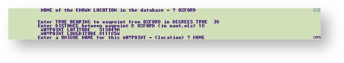
The result is given in Latitudes & Longitudes and give a unique name. The example below shows an abstract location 10 nM, 30 degrees from Oxford.
2 UPDATE an EXISTING location
...
Data required to update an existing location are the same as above:-
...
This is the option used when the location already exists in the data base but some of its information has changed e.g. location or frequency etc. The subsequent menu selected is the same as for the ADD option If two entries with the same location name are made under UPDATE option the last one entered is used by the program i.e the most current entry is utilised. If two entries with the same location name are inadvertently made under the ADD option the later entry will not be accessed.
...
3 Advanced user options
...
| Warning |
|---|
WITH THE POSSIBLE EXCEPTION OF THE SHOW OPTION THESE SHOULD NOT BE USED UNLESS YOU KNOW WHAT YOU ARE DOING.THEY ARE NOT NECESSARY TO GENERAL OPERATION. |
...